Last Summer’s Colorado Trip

Holy cow have I been slacking off on the outdoor blog posts! It was a busy year and I had to let this go for a bit, but let’s get back to it:

Last July it was time to head back to Colorado for the summer adventure. I had to go solo, so I thought I’d go tick off a mountain that had been vexing me and then just see where things took me.

Loaded up the gear, packed the truck and I hit the road early on a Saturday morning.

From Phoenix it’s about 6ish hours to get to Colorado, then it’s some nice driving, the first part, not my favorite.

Around 6 o’clock I pulled into Ridgway State Park, my home for the night. I’d be hiking into the backcountry tomorrow, but it was nice to spend an easy night in the tent at altitude.

It’s a pretty sweet State Park. There’s a real nice lake, quality campsites, and some amazing views! It would be great place to use as a base camp for doing day hikes all around the area.

Mt Sneffels from Ridgway
Ridgway State Park

The next morning I woke up early, packed up and headed for the Blue Lakes Trailhead.

The road to the trailhead is dirt, it’s accessible by 2wd you just have to go slow in a lot of spots. You see all kinds of vehicles out there, I guess you’re only limited by how much you care about your car.

Got there early enough that I got a good parking spot, and took my time organizing my gear. Pretty soon my pack was on and into the woods I went.

It’s very popular place for backpacking and day hikes so you see a decent amount of people on trail. It’s a short, pretty tough hike that goes up hill in about 200 yards from the parking lot. Basically you switchback up the gully until you reach the main basin. There’s a few waterfalls to see but mainly just hiking up in the trees.

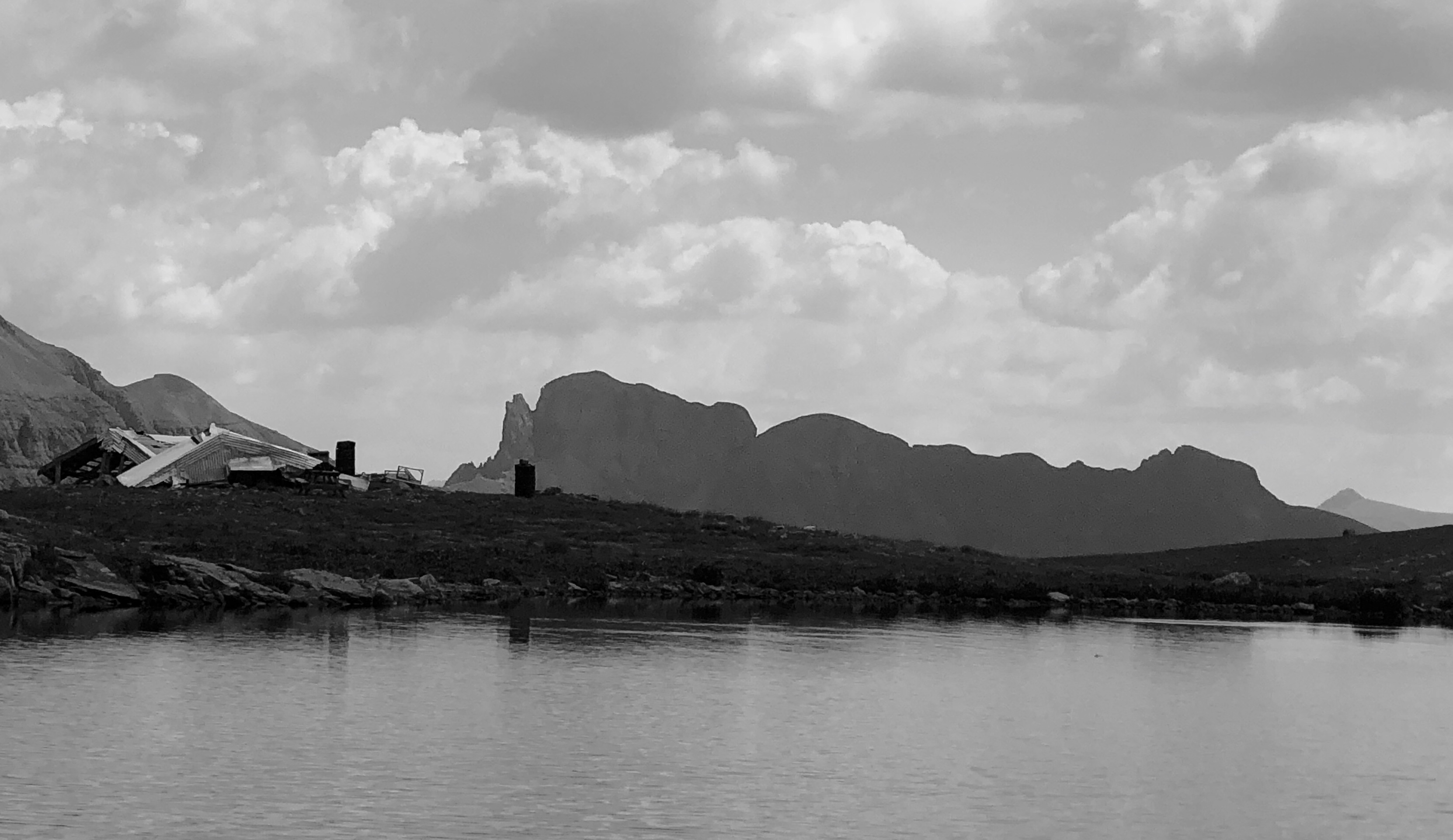
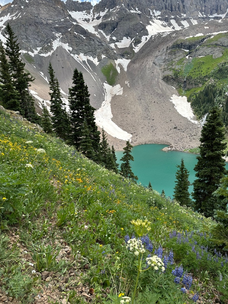
After a little over 3 miles you reach Lower Blue Lake and quickly find that all that effort was worth it!

Lower Blue Lakes

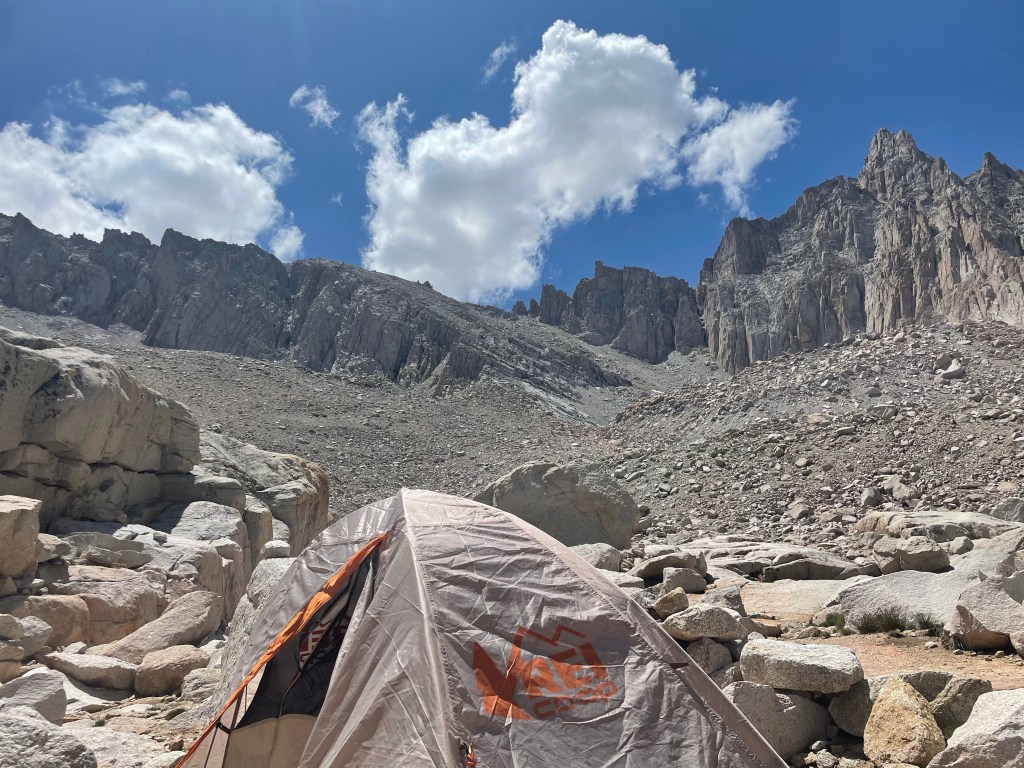
There were a good amount of people camping but I was able to get a nice, relatively secluded spot.

Took my time getting my site set up and had a nice relaxing evening, I was so glad to have my hammock.

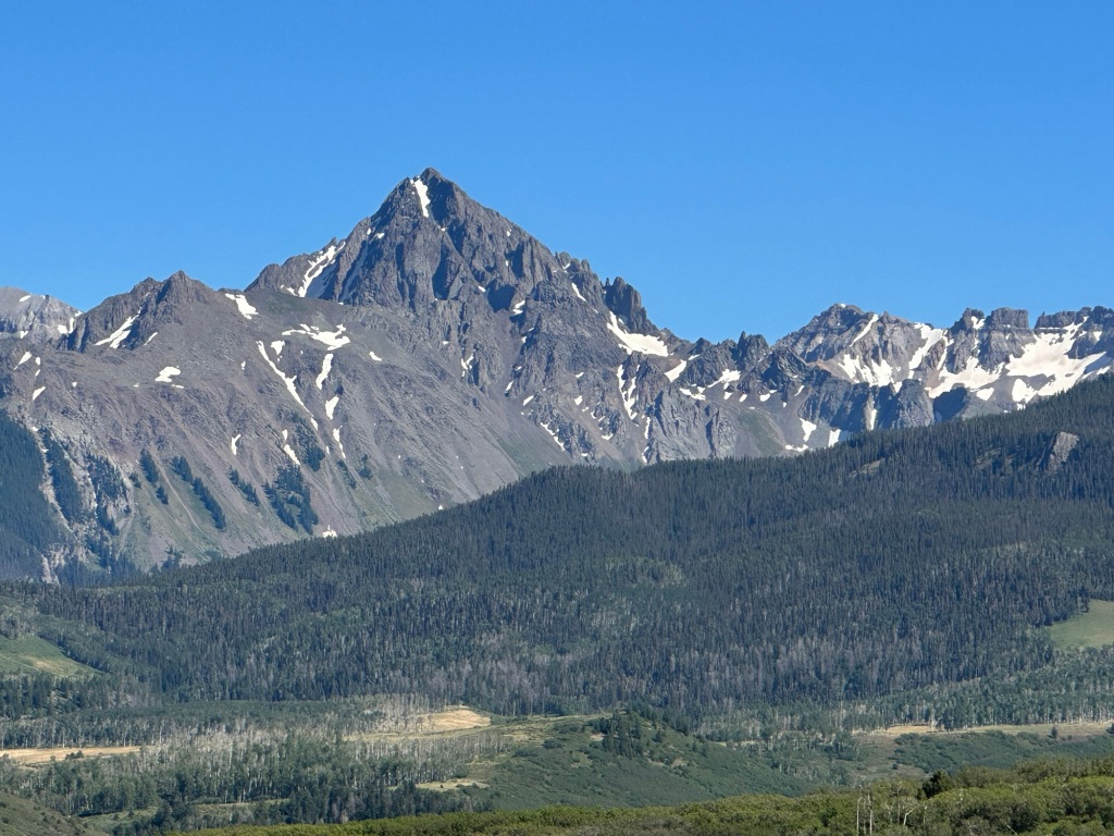
That evening I got ready for the next day’s hike, Mt Sneffels. I had made two other attempts at this mountain, both unsuccessful because of storms (I should have started earlier both times). Summer in Colorado means afternoon storms so I wanted to get on the trail at a solid time.

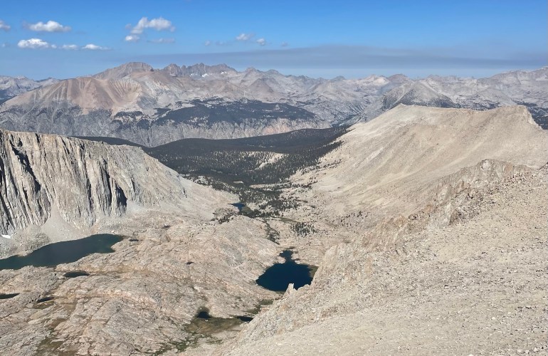
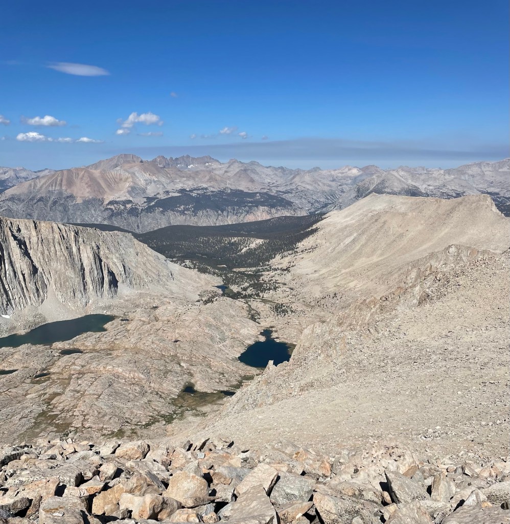
I felt good hiking and in not too long I was standing at 13,000 ft on top of Blue Lakes Pass, looking down on the middle and upper lakes.

Blue Lakes Pass

After that you descend into Yankee Boy Basin, and head towards the Sneffels trail, trying not to think about having to climb up to the pass again…

The next section kind of sucks as you climb the loose scree slope to the saddle. At the saddle you look up the Purple Couloir, the path to the summit.

Purple Couloir

The couloir is full of huge rocks and you navigate up through them to the notch. It was a big snow year so the snowfield up high was pretty long, it was nice to have the axe. I flopped my way up through the notch, not really sure how it get back down, and was headed to the summit.

It’s a cool view from the top, looking all around the San Juans, and east towards the Sangre de Cristo Mountains, I believe. The flys were pretty bad so I headed down after a good look around and a few pics.

Mt Sneffels Summit
Looking down Purple Couloir

Hauled myself back down the notch with the help of some folks coming up, down climbed the snowfield, skated and slipped down the scree, and cursed a little as I climbed back up to Blue Lakes Pass. A little while later after an 8 hour day I was back to camp.

Looking down at Lower Blue Lakes

Back at camp I made myself a snack, sat back and enjoyed being out in the woods, and again the hammock was good.

The next morning it was time to formulate the next plan.

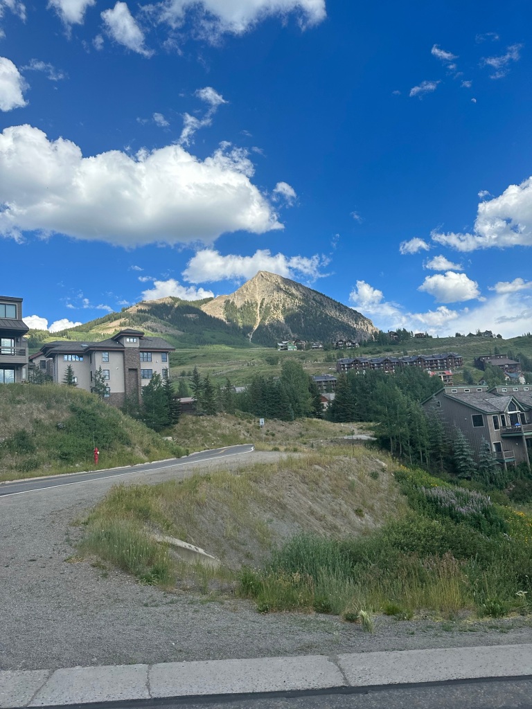
I had thought about heading to Ice Lake near Silverton, but was kind of tired of being by myself in the woods, so I headed over to the old stomping grounds of Crested Butte for a few days.

Mt Crested Butte

Had a nice afternoon walking around town, and was able to have a couple beers with an old friend.

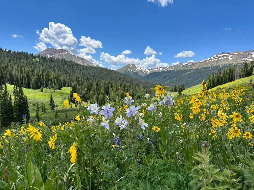
The next morning I headed out to do the West Maroon Creek hike. I didn’t really have a goal, just to hike up high in the amazing alpine!

Made it up to the basin, the wild flowers and mountain views were outstanding, it was great to just hike along in such a beautiful place.

Had a nice dinner in town at The Wooden Nickel, a couple beers and crashed out for the night.

The next morning I was able to have a quick cup of coffee with another old friend I hadn’t seen in 25 years!

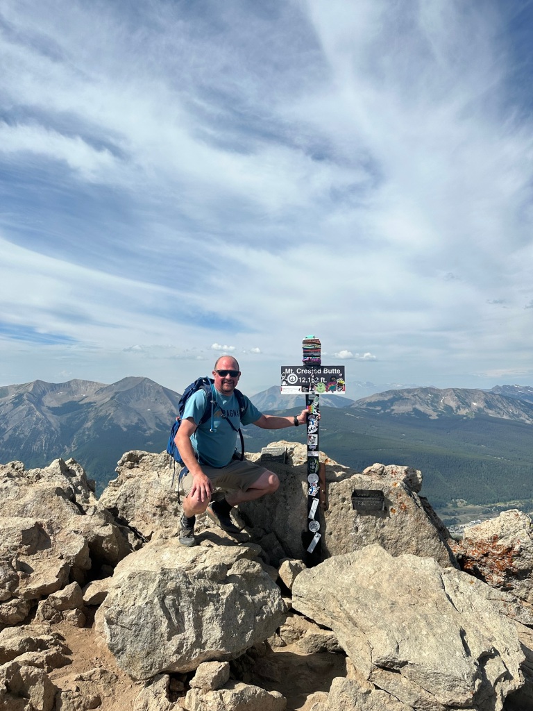
I was planning on making my way back to Phoenix after that but decided to get in one more hike, a little lift assisted hike to the top of Mount Crested Butte. It had been a long time since I stood up there, it was a fun way to end the trip!

Mt Crested Butte Summit

Colorado Hiking Video

Photo of the Week 10.10.22

The aptly named Guitar Lake

Photo of the Week 10.03.22

Looking into Sequoia National Park from Trail Crest, Mt Whitney

Photo of the Week 9/13/21

Blue Lakes Pass, Colorado

Mt Whitney Adventure

After 3 years of trying and the pandemic interrupting my efforts I finally got a Mt Whitney permit! I ended up getting an overnight permit the day they released the unclaimed lottery slots, and planned for 3 nights in the Whitney Zone. That way if I dealt with weather or acclimation issues I would have some extra time.

I headed out on Sunday, July 19th, and made my way to Las Vegas to break-up the drive. Stopped to check out Hoover Dam for a bit. Depressing to see how low the water level is, but it’s always an impressive structure to see!

Hoover Dam from the Mike O’Callaghan–Pat Tillman Memorial Bridge Overlook

I stayed at the El Cortez Hotel just off Fremont Street. I was just looking for a cheap room and it did the job! Strolled around the Fremont Street Experience to do some Vegas people watching, always entertaining!

I wanted to have a nice meal before living out of my backpack for the rest of the week, and luckily wandered in to Carson’s Kitchen just a block away from my hotel. It was exactly what I wanted- Deviled Eggs with Pancetta and Caviar.

Cocoa-Espresso NY Strip, and Glazed Donut Bread Pudding (not pictured because I couldn’t wait to eat it), all amazing!

The next morning I woke up about 5am, grabbed some breakfast and hit the road! My plan was to drive through Death Valley National Park and hit up Badwater, the lowest point in North America, before heading to Mt Whitney, the highest point in the lower 48!

Badwater Basin – Lowest Point in North America

While it is a very different National Park, Death Valley is very beautiful in it’s own way and super cool to drive through.

When I got to Lone Pine I headed down the Whitney Portal Road, but made a stop in the Alabama Hills National Scenic Area. There’s a cool, short loop hike that takes you past some natural rock arches, like Mobius Arch below. Usually you can see Mt Whitney through the arch, but the incoming weather scuttled that view! The area has been used to film many movies from The Lone Ranger (1938) to Iron Man (2008) and many more!

Mobius Arch

After that it was time to make the drive up to the Portal and move in to my campsite for the night.

When I first booked a campsite no spots were open at the Whitney Portal Campground, so I had booked a spot at the Lone Pine Campground at the bottom of the road. I randomly checked a few weeks out and a spot had opened at the Portal campground and I snagged it! This ended up being a great development. The Whitney Portal campground is at 8000 ft and in the beautiful trees, so much better than down in the hot desert!

After getting the tent up I went for a quick hike up the first part of the Mt Whitney trail, just to get the legs moving and to help get used to the altitude. It was nice to hike in such beautiful weather, a big change from Arizona. Spent the evening chillin’ in the campsite enjoying being outdoors!

Whitney Portal Campground

My plan was to hit the trail before 9am. I got up, made myself some breakfast, did a final organizing of the backpack and drove up to the trailhead. Both the hiker lot and overflow parking were full so I had to park on the side of the road, fortunately there’s a large shoulder and it was easy to find a decent spot.

Mt Whitney Trailhead Scale

Weighed my pack at the trailhead scale, 42 lbs, a little on the heavy side but I wanted to have enough food and warm clothes to comfortably stay up high for 4 days if necessary. After that I shouldered the pack and headed down the trail.

The trail starts uphill pretty quickly, makes sense as you’ve got a lot of elevation to gain! After about a mile you enter the John Muir Wilderness, this part of the hike is pretty relaxing overall, just cruising through the forest with some amazing views. The first real milestone is Lone Pine Lake, a cool mountain lake on a rocky shelf about 3 miles in. The trail seems to flatten out a little bit as you head towards Outpost Camp, a popular lower camp inside the Whitney Zone. As you pass Outpost the trail climbs steeply towards Mirror Lake, another amazing lake that’s worth a quick stop!

Entering the John Muir Wilderness

A little ways after you pass Mirror Lake you head above tree line. Most of the rest of the hike is on rocks, and you really start to feel like you’re high in the mountains. The section from Trailside Meadow to Trail Camp felt like the most difficult of the entire hike to me. Maybe I knew I was getting close and was ready to take off the full pack, but I was very glad to have that section behind me.

Looking down the trail towards Trailside Meadow. I found this to be part of the most challenging section.
Consultation Lake

Once you reach Consultation Lake it’s just a short bit up to Trail Camp. I thought about hanging out at the lake, but wanted to go ahead and get a campsite at Trail Camp before the good spots were taken.

I’m happy I was able to make the hike in one push without taking off the pack, I really wanted to be fit for this hike. Arrived at Trail Camp about 12:30ish, found a great little spot, nice and flat and a little sandy for some cushion. Got all set up, got the solar panel going to start charging stuff, had a snack and start hanging out, for about 8 hours…

This is the time it would have been nice to have somebody else along, I met and talked to a few of my tent neighbors and looked around at the beautiful views, but it was a long evening just hanging around.

Trail Camp

I had planned to start hiking by 3am, but it was a cold night at 12,000 ft for this Arizonian. When my alarm went off about 2:30 I decided to be warm for a bit longer and not hike quite as much in the dark, very glad I made this decision!

Cooked up a little oatmeal with peanut butter, threw a few things in my backpack, turned on the headlamp and headed for the summit, a hike I had been waiting a long time to start!

Looking East from the 99 Switchbacks

Trail Camp sits right at the bottom of the 99 Switchbacks so you’re into the business quickly. Overall the switchbacks aren’t steep, there’s just a lot of them and they seem to go on for a long time. Pretty much just put my head down and cranked them out. It was great to get to Trail Crest, it’s an amazing view and a major milestone for the hike. It was cold and windy there so I just kept moving after taking a few pics.

Trail Crest

There’s a sign that says it’s 1.9 miles to the summit, as many have said it’s the longest 2 miles I’ve ever hiked. It took me 1 hour 49 minutes to cover that distance, and I was feeling great and moving at a decent pace the whole time. There are some really cool sections around the JMT junction and a little past that, but after a while you’re just walking through a huge field of rocks, As you continue to head up it seems like you’ll never get there, and then you come over a small ridge of rock and the summit hut is right in front of you! A little navigating through the big rocks and you’re on the summit!

On the Summit!!

I spent about 30 minutes on the summit, got the required summit sign pic. I had cell service, so I was able to call my wife, which was nice! After a bit of taking pics, checking out the hut, it was time to head down. The hike down is pretty easy, just a lot of down.

As I descended I started to run into a lot of the day hikers on their way up. Some people looked great, but there were definitely people who looked like they were struggling pretty badly with a long way to go just to get to the summit, and some who just had no business being there. I hope that they all made wise decisions that day, because as we all know the top is only half way.

I had my GoPro on for the cool section along the JMT junction, but somehow lost all the footage due to operator error!!!

Looking into Sierra National Park

I made it back to Trail Camp about 12:30. Originally I had planned on staying at there again that night, but the prospects of another long afternoon/evening of just hanging out and another cold nights sleep didn’t seem that great. So I packed up camp and hiked on out! The hike out is really cool as well, you kind of get a different perspective than going up. The last mile or so I was ready to be done, a little over 16 miles for the day made the Whitney Portal a welcome sight. Grabbed a burger in Lone Pine, and found a dispersed campsite out in the Alabama Hills. Slept good!

The next day I packed up my campsite and headed back through Death Valley on my way to Zion National Park to continue the adventures!!

Death Valley on the way to Zion!

Photo of the Week 8/17/20

Ice Lake, Colorado

First SUP in a While!

It’s been quite a while since I went out on the Stand-up Paddle-board, with the nice temps in Phoenix right now I had to take advantage!

While April was extremely nice, May started out hot, I believe we’ve hit 107 already this year, so when I saw a high of 87 I knew it was a good afternoon to spend outdoors!

Headed down to Tempe Town Lake after an early out from work. The only real task is getting the SUP inflated, which takes some work. Why I haven’t gotten an electric pump is a fine question, because it’s a solid 5 minutes of pumping!

TTL SUP

I do love having that lake there, so easy for a quick paddle. In 20 minutes I’m on the water!

Happy to be out on the water!

Went from the beach to the far east end of the lake and back, with a little chilling in the middle of the lake. 3.5 miles and one fine afternoon. There was some battling of the wind the whole way back, it always seems to find me!

Photo of the Week 5/18/20

Upper and Middle Blue Lakes – Colorado

Photo of the Week 10/14/19

Alta Lakes, Colorado

Photo of the Week 9/16/19

Fuller Lake